
Climbing to the col and both peaks was an estimated 1600m of climbing in 25km.
It took me 8 hours. Cameron lake is at 1600m elevation, Summit lake is 300m higher
and the col between Carthew and Alderson peaks is about 2205m. The peaks are
2692m for Alderson and 2630m for Carthew. Bertha in the distance is only 2440m.
I was originally going to hike back to the Waterton townside; but the trail
around Bertha Mtn. was closed due to heavy deadfall from the spring storms.
7:17 @ Cameron Lake, 7:35 hiking
8:30 Summit lake - 2 wide picture with 50mm then 28mm
9:30 Col overlooking 2 lakes - 2 wide shot, trails forking
3 wide shot of Carthew and Alderson peaks
10:55 at top of Alderson, cairn, peak was always further away
4 wide shot forwards, 2 wide backwards
11:30 leaving peak (17 pictures into new roll), 12:20 back at Col
12:54 boots off at top of Carthew - Easy but hardish bit on slop
3:30 done hike
Nice view of Bertha lake with USA mountains behind it from peak.


At this point the trail continues up along a ridge. In the distance you can see
the ridge which some more switchbacks climb. When you're up there; the view gets
a lot better.


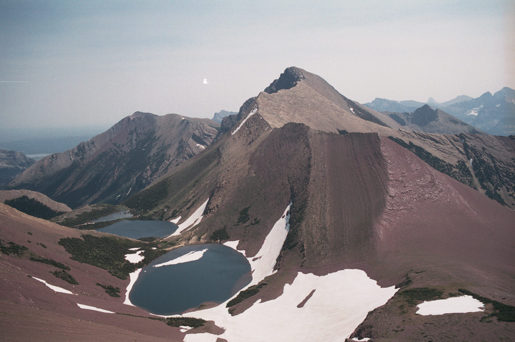
Once you are up on the col; you can continue along it to the this little peak; and from there you get a good
view of Mt. Carthew.

Mt Carthew as seen from a view point along the col. The trail up is visible on the lower left. The trail along
the col is not actually part of the hiking trail as the trail continues to the right to Carthew Lakes.

Here is Mt. Alderson and the ridge that you follow to the peak. It takes longer than you'd think. Mt. Carthew
is the easier climb. The ridge to the peak of Alderson does require you to keep on the left or the right side
at points if you want to avoid climbing.


At this point I'm perhaps 1/2 of the way up Mt. Alderson. The trail down from col and ridge is just visible in the
distance. From here it is quite clear that the path to the peak isn't just as simple as walking up and up!
In the distance is Akamina Ridge, a hike in Akamina-Kishinena Prov. Park. I highly suggest doing that hike to get
a great view into Waterton.

Here is an interesting view. Middle Waterton lake is seen behind Bertha Mtn (2440m) and Upper Waterton
Lake to the right. There is a Bertha Lake hike going to a nice lake from
which you can apparently "scramble" up to the peak of Bertha Mtn. It didn't look very easy or
much fun from the lake!

This set of 6 pictures are first shown joined in groups of two and then as a complete set.
You'll note that the tiled picture curves up in the middle - because I had the camera pointing
down when I took the pictures.


At this point I'm descending. The 2nd picture is a view of Mt Carthew. The hike (not really a scramble) of Carthew
is simply a walk up the shallow slope on the left.


This view looks down the ascent to Mt. Carthew. Wurdeman lake is in the distance, just behind the ridge which you
climb to gain the view of the Carthew lakes and peaks. The only hard part of this climb is the part from the ridge
to the nice wide ridge you walk to the peak. That part is either walking along the side of the peak (where you see
the rock layers) or the loose scree on the other side. It's note very hard; but a bit unsettling if you've never
ventured off of a trail.

I'm now returning to Cameron lake. This view is towards the USA. Cameron lake is visible on the right as a dark blue
and the light blue lake in the distance is Wurdeman Lake.
